
Michigan Road Maps | Detailed Travel Tourist Drivig
|
Michigan Road Maps |
Michigan
- $14.95
Item Code : GMJO22888
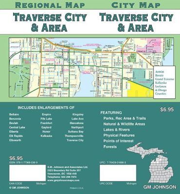 Scale 1:32,000. Size 27"x39". G.M. Johnson edition. This Map Coverage Area are Bellaire, Benzonia, Beulah, Central Lake, Elberta, Elk Rapids, Ellsworth, Empire, Fife Lake, Frankfort, Gaylord, Honor, Kalkaska, Kingsley, Lake Ann, Mancelona, Northport, Suttons Bay, Thompsonville, Traverse City.
 - $249.95 + $24.80 p&h (add $40 for spring rollers)
Item Code : UNIV10591
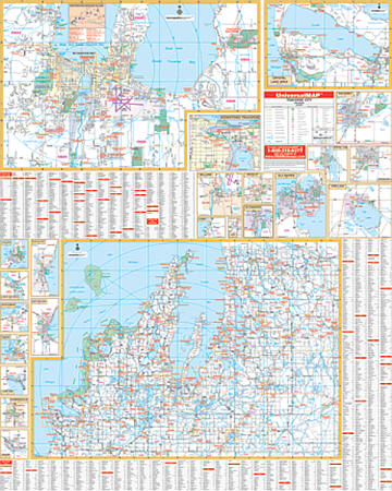 Size 54" W x 69" H. Laminated. Printed in color with a markable/washable-laminated surface. Streets are indexed on the face of the map. Includes hanging rails mounted top and bottom. Area of coverage includes a vicinity map of the Grand Traverse Bay area, Benzie County, and portions of Leelanau and Kalkaska Counties, and Antrim County. Inset includes the following: Grand Traverse County: Fife Lake; Kingsley; Traverse City Benzie County: Benzonia; Honor; Lake Ann; Thompsonville; Beulah Kalkaska County: Kalkaska Leelanau County: Empire; Lake Leelanau; Leland; Northport; Glen Arbor; Suttons Bay Antrim County: Bellaire; Central Lake; Elk Rapids; Ellsworth; Mancelona Downtown Traverse City and Northwest Michigan. Details include streets and highways, government buildings, airports, water features, fire/police stations, hospitals, shopping centers, educational facilities, railroads, recreational parks, golf courses and country clubs, ZIP codes/boundaries, mileage circles, and longitude/latitude lines. Railed wall maps can be turned into pull down maps on spring rollers for an additional $40.
 - $14.95
Item Code : GMJO22889
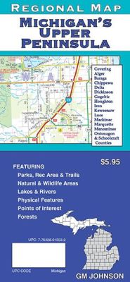
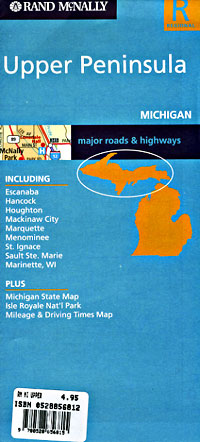
 Scale 1:384,000. Size 27"x39". G.M. Johnson edition. This Map Coverage Area are Alger, Baraga, Chippewa, Delta, Dickinson, Gogebic, Houghton, Iron, Keweenaw, Luce, Mackinac, Marquette, Menominee, Ontonagon & Schoolcraft Counties, Baraga, Escanaba, Hancock, Houghton, Iron Mountain, Ironwood, Isle Royale, Kingsford, L’anse, Mackinac Island, Manistique, Marinette WI, Marquette, Menominee, Sault Ste. Marie, St. Ignace.
 - $10.95
Item Code : RAND10592
 Scale 1:615,000. Size 26"x36". Rand McNally edition.
 - $10.95
Item Code : RAND10594
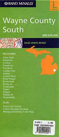
Wayne County, North, and Detroit, Michigan, America. -
- $10.95
Item Code : RAND10595
 Scale 1:39,000. Size 26"x40". Rand McNally edition.
 - $29.95
Item Code : NATL20980
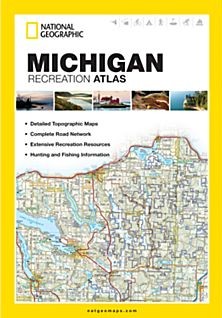
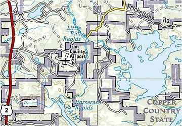 Scale 1:175,000. Size 11"x15". National Geographic edition. National Geographic's Michigan Recreation Atlas is an ideal recreation resource and contains accurate, detailed topographic maps with private and public land boundaries, a complete road network, valuable recreation information and extensive cross-referenced lists and charts for campgrounds, lakes, parks, attractions, and more. State Game Management Unit maps and fish species lists appeal to the sportsman while detailed primary road networks are of great interest to motorcyclists, RVers, and those simply touring the state. Key features: Detailed topographic maps with shaded relief for the entire state Each labeled feature is up to date and verified by satellite image Comprehensive, easy-to-read road network Boundaries for parks and federal lands Clearly-labeled lakes, rivers and streams Durable laminated cover Robust travel and recreation information Cross-referenced chart of fishing areas with species information Game management units Campgrounds and attraction charts State Parks maps and facilities Hiking, golfing, skiing and paddling destinations Climate information.
|
Michigan Road Maps |
My Wish List
Last Added Items
You have no items in your wish list.
