
Florida City Maps, O to Z | Detailed, Travel, Tourist Street
|
Florida City Street Maps |
Florida City Maps, O to Z
- $14.95
Item Code : GMJO22670
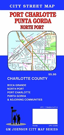
 G.M. Johnson edition. An accurate and detailed city street map of Port Charlotte, FL. Also covers Boca Grand, North Port, Charlotte County, Punta Gorda & Adjoining Communities.
 - $26.95 + $7.50 p&h or $28.50 foreign delivery
Item Code : AMER18482
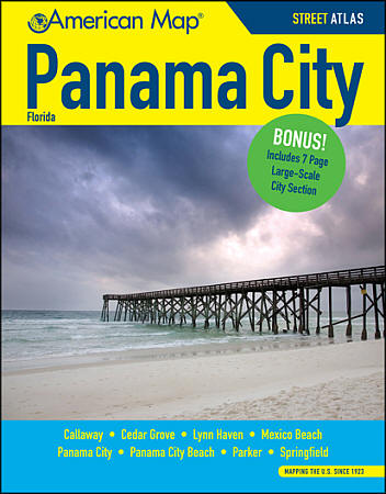 Size 8?"x11". 130 pages. American Map Company edition. The Panama City street atlas features clear detailed mapping of the Panama City area including Callaway, Cedar Grove, Lynn Haven, Mexico Beach, Panama City Beach, Parker, and Springfield. It includes places of interest and large scale maps for Panama City, as well as a comprehensive index with places, streets, and places of interst. (We only sell the latest edition of this street atlas, whatever the year may be. The illustration is for visual purposes only.)
 - $249.95 + $24.80 p&h (add $40 for spring rollers)
Item Code : UNIV18483
 Scale 1:2,640. Size 78"x 72". Laminated. Printed in color with a markable/washable--laminated surface. Street index provided in a separate book. Framing rails are included on top and bottom for easy wall mounting. Railed wall maps can be turned into pull down maps on spring rollers for an additional $40. Area of coverage: All of Bay County including the following cities, towns, and localities: Panama City, Callaway, Cedar Grove, Hiland, Lynn Haven, Parker, Springfield, Southport, Vicksburg, West Bay, Panama City Beach, and the beaches of South Walton County, plus Tyndall Air Force Base. Insets: Mexico Beach--North Bay Co. Details include all streets and highways, government buildings, airports, water features, fire/police stations, hospitals, shopping centers, educational facilities, railroads, recreational parks, golf/country clubs, post offices, city limits/annexations, cemeteries, ZIP codes/boundaries, subdivision names, section/township/range lines, and points of interest.
 - $249.95 + $24.80 p&h (add $40 for spring rollers)
Item Code : UNIV18501
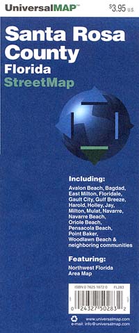
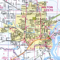
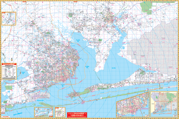 Scale 1:2,640. Size 77"x 54". Laminated. Provides up-to-date cartography with new streets and changes, printed in color with a markable and washable laminated surface, and framing rails mounted on the top and bottom for ease in hanging . Indexed in a separate book. Map Coverage: North: East Black-Water River State Park and 3 miles north of Stonebrook Golf Course; South: to the Gulf of Mexico, including Pensacola Beach, Navarre Beach, and the Pensacola Naval Air Station; East: to the Okaloosa Co. line. West: to the Alabama State line; Northwest: Cottage Hill and Cantonment. Details include: airports, cemeteries, hospitals, railroads, post offices, points of interest, longitude and latitude lines, all streets and highways, shopping centers, water features, recreational parks, fire districts, city limits and annexations, government buildings, fire and police stations, educational facilities, golf courses and country clubs, mileage circles, ZIP codes/boundaries, and section/township/and range lines. Includes an inset map of Pensacola, Jay, Northwest Florida. Railed wall maps can be turned into pull down maps as a $40 option.
 - $24.95 + $7.50 p&h or $28.50 foreign delivery
Item Code : AMER18502
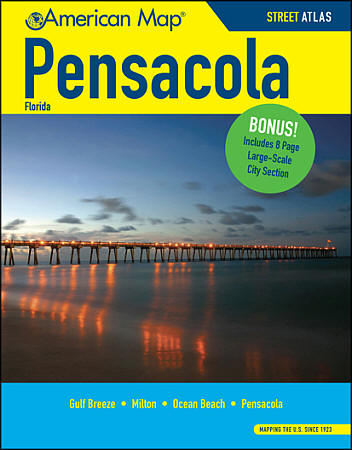 Size 8?"x11". 146 pages. American Map Company edition. The Pensacola street atlas features clear detailed mapping of the Pensacola area including Gulf Breeze, Milton, and Orange Beach. It includes places of interest and large scale maps for Pensacola, as well as a comprehensive index with places, streets, and places of interst. (We only sell the latest edition of this street atlas, whatever the year may be. The illustration is for visual purposes only.)
 - $249.95 + $24.80 p&h (add $40 for spring rollers)
Item Code : UNIV18506
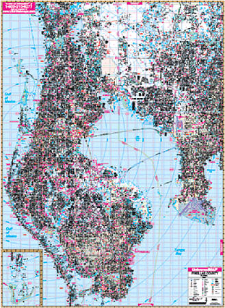 Scale 1:2,640. Size 77"x 54". Laminated. The 6th edition Pinellas County, Florida Wall Map by Universal Map measures 54" x 77" (4'6" W x 6'5" H) and is printed in color with a laminate surface which is markable and washable. Provides complete street detail with up-to-date cartography showing new streets and changes. Streets are indexed in a separate book. Framing rails are included on top and bottom for easy wall mounting. Boundaries as follows: North: to the Pasco County line; South: to the Gulf of Mexico; East: includes Hillsborough County to US41 with McDill Air Force Base and Tampa International Airport; West to the Gulf of Mexico. Special features and data are as follows: all streets and highways, government buildings, ZIP codes and ZIP code boundaries, airports, golf courses and country clubs, water features, city limits and annexations, township-section-and range lines, post offices, shopping centers, cemeteries, points of interest, mileage circles, block numbers, educational facilities, fire and police stations, hospitals, recreational parks, subdivision names on map, and railroads. Railed wall maps can be turned into pull down maps as a $40 option.
 - $229.95 + $24.80 p&h (add $40 for spring rollers)
Item Code : UNIV18516
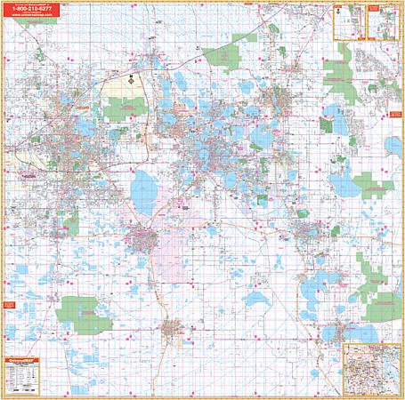 Scale 1:3,100. Size 72"x 72". Laminated. The 5th Edition Polk County, Florida Wall Map from Universal Map contains up-to-date cartography with new streets and changes, complete street detail and a laminated surface making the map markable and washable, and street indexing in a separate book. The area of coverage ranges North: to the Osceola County Line (Exit 58 on I-4); South:to the Highlands and Hardee County lines; East: includes Poiciana, and Lake Hatchineha; West: to the Hillsborough County line. Insets: vicinity map of Polk County; northern Polk County, along US27 to the Lake County Line. Details include: all streets and highways, post offices, hospitals, railroads, mileage circles, airports, cemeteries, shopping centers, water features, recreational parks, longitude and latitude lines, government buildings, fire and police stations, educational facilities, golf courses and country clubs, ZIP codes and boundaries, city limits and annexations, and section-range-township lines. Framing rails are included on top and bottom for easy wall mounting. Railed wall maps can be turned into pull down maps as a $40 option.
 - $229.95 + $24.80 p&h (add $40 for spring rollers)
Item Code : UNIV18522
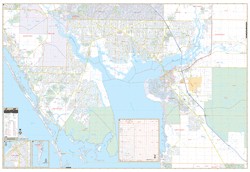 Scale 1:2,280. Size 74"x 54". Laminated. The area of coverage includes all of western Charlotte County with the following boundaries: North: to include Northport and Venice in Sarasota County; South: includes Placida, intersection of CR 775 and 771, and Boca Grande Causeway; East: to US Route 17, including Peace River Shores, Ridge Harbor and Cecil M. Webb Wildlife including Tropical Gulf Acres; West: to the Gulf of Mexico. Insets: Charlotte County, and Burnt Store, Gasparilla Island in Lee County Balance of Eastern Charlotte County at a reduced scale. Details include all streets, post offices, hospitals, railroads, mileage circles, airports, cemeteries, shopping centers, water features, recreational parks, government buildings, fire and police stations, educational facilities, mobile home parks, longitude and latitude lines, range/township/section lines, city limits/annexations, golf courses and country clubs, and ZIP code numbers/boundaries. Framing rails are included on top and bottom for easy wall mounting. Railed wall maps can be turned into pull down maps as a $40 option.
 - $249.95 + $24.80 p&h (add $40 for spring rollers)
Item Code : KAPA21101
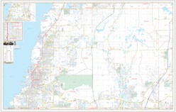 Our West Pasco County, FL Wall Map, with adjacent areas, measures 77" x 49" (6'5" W x 4'1" H) and features up-to-date cartography, with new streets and changes in complete street detail; is printed in color, with a markable and washable laminated surface; and offers a street index in a separate book-format. The area of coverage includes all of West Pasco County, with the following boundaries: - North to the Pasco County line - South to the Pasco County line - East to I-75 - West to the Gulf of Mexico The West Pasco County, FL Wall Map also includes a Pasco County area map. Details and features include: - AIRPORTS - CEMETERIES - CITY LIMITS (color-coded) - EDUCATIONAL INSTITUTIONS - FIRE & POLICE STATIONS - GOLF & COUNTRY CLUBS - GOVERNMENT BUILDINGS - HOSPITALS - LIBRARIES - POINTS OF INTEREST - POST OFFICES - RAILROADS - RECREATIONAL PARKS - SECTION, TOWNSHIP & RANGE LINES - SHOPPING CENTERS - STREETS & HIGHWAYS - WATER FEATURES - ZIP CODE BOUNDARIES Framing rails are included, top and bottom, for easy wall mounting. Spring roller mounting is also available, for an additional $40.
 - $249.95 + $24.80 p&h (add $40 for spring rollers)
Item Code : KAPA21102
 Our Polk County, FL Wall Map, with adjacent areas, measures 72" x 75" (6' W x 6'3" H) and features up-to-date cartography, with new streets and changes in complete street detail; is printed in color, with a markable and washable laminated surface; and offers a street index in a separate book-format. The area of coverage includes Polk County, Lakeland, and Winter Haven, as well as the following boundaries: - North to Deen Still Road - South to Highlands and Hardee County lines - East to Poinciana, Lake Hatchineha, and Lake Weohyakapka - West to the Hillsborough County line The Polk County, FL Wall Map also includes inset maps of Polk County vicinity and northern Polk County, along US 27 to the Lake County line. Details and features include: - AIRPORTS - BLOCK NUMBERS - CEMETERIES - CITY LIMITS - EDUCATIONAL INSTITUTIONS - GOLF & COUNTRY CLUBS - GOVERNMENT BUILDINGS - HOSPITALS - LIBRARIES - POLICE STATIONS - RAILROADS - RECREATIONAL PARKS - SHOPPING CENTERS - STREETS & HIGHWAYS - WATER FEATURES - ZIP CODE BOUNDARIES Framing rails are included, top and bottom, for easy wall mounting. Spring roller mounting is also available, for an additional $40.
 - $10.95
Item Code : UNIV22669
Universal Map edition. This map of Palm Beach County, FL is durably laminated and contains extensive coverage. Laminated maps are easy to fold, write on, and wipe off. Coverage includes street-detail maps of Palm Beach and West Palm Beach; and features: Airports, Colleges and Universities, Golf Courses, Parks and Rec Areas, Places of Interest, and ZIP Codes. - $10.95
Item Code : UNIV18527
 Scale 1:44,000. Size 28"x40". Universal Map edition.
 - $10.95
Item Code : AMER18529
 Scale 1:43,000. Size 27"x40". American Map Company edition.
 - $10.95
Item Code : UNIV18530
 Scale 1:45,000. Size 24"x36". Universal Map edition.
 - $10.95
Item Code : RAND18531

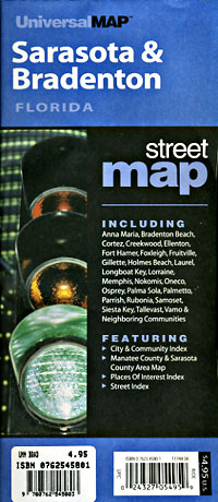
 Scale 1:42,000. Size 28"x40". Rand McNally edition. Rand McNally's folded map featuring the streets of Sarasota and Bradenton is a must-have for anyone traveling in and around this part of Florida, offering unbeatable accuracy and reliability at a great price. Our trusted cartography shows all Interstate, U.S., state, and county highways, along with many smaller roads and streets, too. You'll see why Rand McNally folded maps have been the trusted standard for years.
 - $249.95 + $24.80 p&h (add $40 for spring rollers)
Item Code : UNIV18537
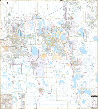
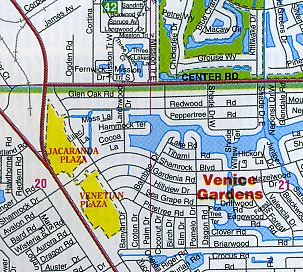
Scale 1:2,600. Size 58"x 73". Laminated. Provides up-to-date cartography with new streets and changes. Printed in color with a markable/washable-laminated surface. Streets indexed on the face of the map. Includes hanging rails mounted top and bottom. The area of coverage includes all of Sarasota County with the following boundaries: North: to the Manatee County line; South: to the Charlotte County line; East: to the DeSoto County line, including Myakka River State Park; West: to the Gulf of Mexico. Inset: Northport. Details provided: airports, all streets/highways, government buildings, cemeteries, shopping centers, fire/police stations, hospitals, water features, educational facilities, railroads, recreational parks, golf/country clubs, post offices, mobile home parks, ZIP codes/boundaries, city limits/annexations, and section/township/range lines. Railed wall maps can be turned into pull down maps on spring rollers for an additional $40. - $229.95 + $24.80 p&h (add $40 for spring rollers)
Item Code : UNIV18528
Laminated. Universal Map Wall Maps provide up-to-date cartography showing new streets and changes. Plotted in complete street detail. Printed in color with a markable/washable-laminated surface. Provides street indexing on the face of the map or in a separate book. Framing rails are included on top and bottom for easy wall mounting. Railed wall maps can be turned into pull down maps on spring rollers for an additional $40. - $10.95
Item Code : ADCM18536
Maps edition. Laminated, easy-fold "Slicker" - $10.95
Item Code : RAND18543
 Scale 1:45,000. Size 28?"x40". Rand McNally edition.
 - $10.95
Item Code : UNIV18544
 Scale 1:43,000. Size 24"x36". Universal Map edition.
|
Florida City Street Maps |
