
United States Road Maps | Detailed Travel Tourist Driving
|
United States Road Maps |
United States
- $16.95
Item Code : NATL20968
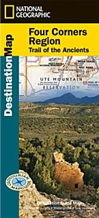 Scale 1:6,400,000. Size 30"x42". National Geographic edition. National Geographic’s Four Corners Region Destination Map strikes the perfect balance between map and guidebook and is ideal for a wide range of travelers. The Four Corners Region is the only place in the United States where four states intersect at one point: Arizona, Colorado, New Mexico and Utah. The map guide seeks to contribute to the economic health of communities in the Four Corners Region by promoting geotourism: tourism that sustains or enhances the geographical character of a place—its environment, culture, aesthetics, heritage and the well-being of its residents. The Four Corners Region Destination Map is printed on durable, waterproof and tear-resistant material. The front side of the Four Corners Region Destination Map reveals a map of the region spanning from Dixie National Forest in southeastern Utah; to Great Sand Dunes National Park and Preserve and San Isabel National Forest in southwestern Colorado; to Santa Fe National Forest and Cibola National Forest in northwestern New Mexico; to Coconino National Forest in northeastern Arizona. At the center of the map is the Four Corners Monument, where visitors can stand on the only spot in the United States where four states meet. The map also includes a detailed road network and areas of interest such as Indian Reservations and National Parks, Forests, Monuments and Recreation Areas. Archaeological sites, historic sites, museums, scenic areas, geotourism locations, state parks and other points of interest are also featured. The reverse side of the map provides invaluable content for travelers with individual maps and descriptions highlighting archaeological sites, festivals, museums and events; outdoor recreation opportunities; water and geologic features; and arts, music and cultural points of interest. The map also features important travel tips and beautiful photographs showcasing some of many ways travelers can experience this enchanted landscape. Key Features: Chart of the Four Corners Region’s national parks including services and contact information Colorful photographs featuring the region’s diverse terrain National parks and monuments, geotourism places of interest, historic sites and more Descriptive content and individual maps highlighting archaeological sites, outdoor recreation opportunities, water and geologic features, and arts, music and cultural points of interest.
 - $17.95
Item Code : ITMB21200
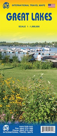 Scale 1:1,000,000. Size 27"x39". International Travel Maps edition. To North Americans, there is only one “Great Lakes” – the waterway stretching far into the interior of the continent from the Gulf of St. Lawrence to the tip of Lake Superior. This vast region has exerted a fundamental hold on the development of both the USA and Canada; first as a canoeing trade route for trapping furs, then as a means of settlement, and now as a water route to move products to world markets. The region is also densely populated with well-known touristic cities and attractions, and houses in excess of 100,000,000 people. Surprisingly, until now, there has never been a map for this interesting and historic part of the continent. Using this map, one can explore Lakes Ontario and Erie as circular routes; also Huron and Superior; visit Ottawa and Toronto, Chicago and Duluth, and find Fort William or the Wawa Goose. This is a double-sided map covering from Ottawa in the north to Pittsburgh and Columbus in the south and Duluth and Thunder Bay in the west. Both Canada and the USA portions of the Great Lakes Region are included.
 - $229.95 + $24.80 p&h (add $40 for spring rollers)
Item Code : UNIV4834
Scale 1:8,000,000. Size 54" W x 64" H. Laminated. The New England States Wall Map published by Universal Map includes Maine, New Hampshire, Massachusetts, Connecticut, and Rhode Island with an Eastern Massachusetts inset. Printed in color with a markable and washable laminated surface. Indexed on the face of the map. Includes hanging rails mounted top and bottom. Details major airports, major waterways, state and national parks, all state and federal highways, military installations, cities and towns, and points of interest. Railed wall maps can be turned into pull down maps on spring rollers for an additional $40. - $229.95 + $24.80 p&h (add $40 for spring rollers)
Item Code : UNIV4835
Scale 1:9,500,000. Size 54" W x 64" H. Laminated. The 1st Edition Railed New England States Wall Map published by Universal Map includes Maine, New Hampshire, Massachusetts, Connecticut, Vermont, and Rhode Island. Printed in color with a markable and washable laminated surface. Indexed on the face of the map. Includes hanging rails mounted top and bottom. Details major airports, major waterways, state and national parks, all state and federal highways, military installations, cities and towns, and points of interest. Railed wall maps can be turned into pull down maps on spring rollers for an additional $40. - $229.95 + $24.80 p&h (add $40 for spring rollers)
Item Code : UNIV4836
Scale 1:9,500,000. Size 54" W x 64" H. Laminated. The 1st Edition Railed New England States Wall Map published by Universal Map includes Maine, New Hampshire, Massachusetts, Connecticut, Vermont, and Rhode Island. Printed in color with a markable and washable laminated surface. Indexed on the face of the map. Includes hanging rails mounted top and bottom. Details major airports, major waterways, state and national parks, all state and federal highways, military installations, cities and towns, and points of interest. Railed wall maps can be turned into pull down maps on spring rollers for an additional $40. - $16.95
Item Code : HLWG4862
 Scale 1:1,200,000. Size 39"x54". Hallwag edition. Laminated card cover. U of the
|
United States Road Maps |
My Wish List
Last Added Items
You have no items in your wish list.
