
Ohio Road Maps | Detailed Travel Tourist Driving
|
Ohio Road Maps |
Ohio
- $15.95 + $5.80 p&h or $14.80 foreign delivery
Item Code : UNIV12104
 Scale 1:33,000. Size 8?"x11". 76 pages. Universal Map edition.
 - $10.95
Item Code : UNIV12107
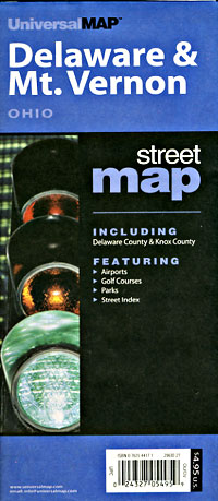
 Vernon, Ohio, America. "Various scales". Size 23"x35". Universal Maps edition.
 - $10.95
Item Code : UNIV12108
 Scale 1:29,000. Size 16"x27". Universal Maps edition.
 - $249.95 + $24.80 p&h (add $40 for spring rollers)
Item Code : UNIV12106
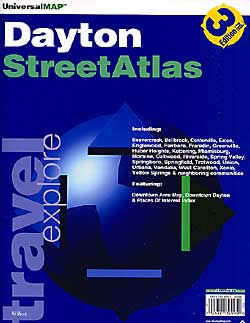
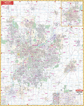 Scale 1:2,816. Size 54" W x 69" H. Laminated. The Dayton, Ohio and adjacent areas Wall Map by Universal Map. Printed in color with a markable and washable surface. Area of coverage ranges: North: to West Milton, Tipp City, and New Carlisle; South: to Waynesville, Corwin, and Franklin; East: to Yellow Springs and Xenia; West: to Germantown and Sycamore State Park. Insets include Springfield, a vicinity map, and Downtown Dayton. The special features and data are as follows: all streets, all highways, educational facilities, government buildings, shopping centers, hospitals, airports, recreational parks, post offices, golf and country clubs, points of interest, city limits and annexations, railroads, mileage circles, water features, cemeteries, fire and police stations, ZIP code and boundaries. In addition, for your convenience, the map is indexed in a separate book. Framing rails are included on top and bottom for easy wall mounting. Railed wall maps can be turned into pull down maps on spring rollers for an additional $40.
 - $10.95
Item Code : UNIV12110
 Scale 1:24,000. Size 19"x25". Universal Maps edition.
 - $10.95
Item Code : UNIV12109
Universal Maps edition - $10.95
Item Code : RAND12112

 Scale 1:36,000. Size 36"x45". Rand McNally edition.
 -
- $10.95
Item Code : UNIV12117
 Scale 1:60,000. Size 27"x39". Universal Maps edition.
 - $10.95
Item Code : UNIV12118
 Scale 1:28,000. Size 21"x27". Universal Maps edition. Detailed city street map.
 -
- $249.95 + $24.80 p&h (add $40 for spring rollers)
Item Code : UNIV12115
 Size 64" W x 54" H. Laminated. The Lake and Geauga Counties, Ohio Wall Map by Universal Map contains up-to-date cartography, complete street detail, lamination, and full-color. Coverage ranges north to Lake Erie; south to the Geauga-Portage County line; east to the Lake-Geauga County Line with Ashtabula and Trumble County lines; and west to the Cuyahoga County Line. Details all streets, post offices, hospitals, railroads, mileage circles, municipal township names/boundaries, airports, cemeteries, shopping centers, water features, recreational parks, government buildings, fire/police stations, educational facilities, golf courses/country clubs, and ZIP codes/boundaries. Framing rails are included on top and bottom for easy wall mounting. Railed wall maps can be turned into pull down maps on spring rollers for an additional $40.
 - $229.95 + $24.80 p&h (add $40 for spring rollers)
Item Code : UNIV12120
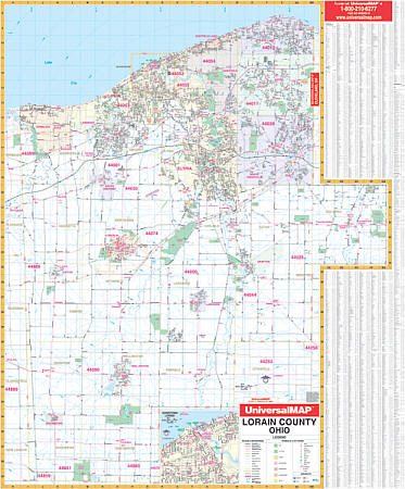 Size 42" W x 54" H. Laminated. Provides complete street detail with up-to-date cartography, new streets and changes, color with a markable and washable laminated surface. Indexed on map's face. Framing rails are included on top and bottom for ease in hanging. Area of coverage: all of Lorain County with the following boundaries: North: to Lake Erie; South: to the Lorain/Ashland County lines; East: to the Lorain/Cuyahoga County lines; West: to the Lorain /Erie/Huron County lines. Included is an inset map of Downtown Lorain. Details and information included: airports, cemeteries, hospitals, railroads, post offices, township names, all streets and highways, shopping centers, water features, recreational parks, mileage circles, city limits and annexations, government buildings, fire and police stations, educational facilities, golf courses and country clubs, ZIP codes and boundaries, longitude/latitude lines, and points of interest. Railed wall maps can be turned into pull down maps on spring rollers for an additional $40.
 - $10.95
Item Code : UNIV12121
 "Various scales". Size 27"x40". Universal Map edition.
 - $10.95
Item Code : UNIV12122
 Size 23"x34". Universal Map edition.
 -
-
- $14.95
Item Code : GMJO12124
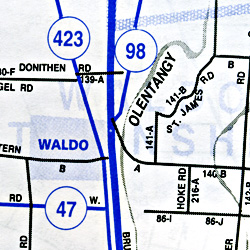
 Scale 1:32,000. Size 27"x39". G.M. Johnson edition.
 - $14.95
Item Code : GMJO12125
 Scale 1:32,000. Size 27"x39". G.M. Johnson edition.
 - $10.95
Item Code : UNIV12126
 Scale 1:39,000. Size 25"x38". Universal Maps edition.
|
Ohio Road Maps |
