
Iowa Road Maps | Detailed Travel Tourist Driving
|
Iowa Road Maps |
Iowa
-
- $229.95 + $24.80 p&h (add $40 for spring rollers)
Item Code : UNIV9302
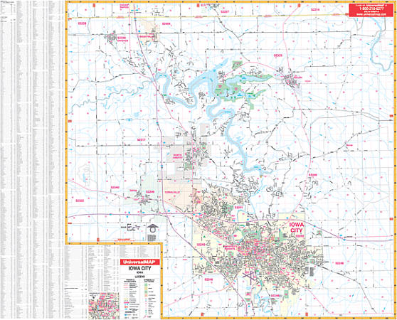 Scale 1:550,000. Size 65" W x 55" H. Laminated. The 1st. edition Iowa City, Iowa and adjacent areas Wall Map by Universal Map. Printed in color with a markable and washable laminated surface. Streets are indexed on the face of the map. Has hanging rails mounted top and bottom for ease in hanging. Covers all of Iowa City with the following boundaries: North: to the Linn County line; South: to Osage Street, Pleasant Valley Golf Course; East: includes Morse and Solon to Wapsi Avenue; West: includes Swisher to Green Castle Avenue. Includes an inset map of Downtown Iowa City. Shows: airports, all streets and highways, government buildings, cemeteries, shopping centers, golf and country clubs, hospitals, water features, educational facilities, railroads, recreational parks, longitude and latitude lines, mileage circles, ZIP codes and boundaries, city limits and annexations, section/township/range lines, and points of interest. Railed wall maps can be turned into pull down maps on spring rollers for an additional $40.
 - $10.95
Item Code : UNIV9301

 Scale 1:25,000. Size 18"x23". Universal Map edition.
 - $10.95
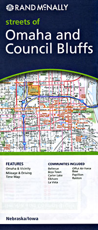
Item Code : UNIV9304
Scale 1:50,000. Size 27"x39". Universal Map edition. This full-color street map of Omaha, NE and Council Bluffs, IA includes: Bellevue, Boys Town, Carter lake, La Vista, and Ralston; and features: Airports, Colleges and Universities, Golf Courses, Hospitals, Omaha Downtown, Parks and Rec Areas, Places of Interest, and ZIP Codes. - $10.95
Item Code : RAND9305
 Scale 1:38,000. Size 28"x40". Rand McNally edition.
 - $10.95
Item Code : UNIV9306
Scale 1:31,000. Size 28"x40". Indexed. Universal Maps edition. - $249.95 + $24.80 p&h (add $40 for spring rollers)
Item Code : UNIV9308
Scale 1:130,000. Size 60" W x 54" H. Laminated. Provides up-to-date cartography with cities and towns indexed on the face of the map. Printed in color with a markable/washable-laminated surface. Mounted on hanging rails.The area of coverage includes all of the following 6 counties: Cedar, Clinton, Muscatine, and Scott Iowa: Mercer and Rock Island, Illinois; and portions of the following counties: Jones and Louisa, Iowa, and Henry, Knox, and Whiteside, Illinois. Boundaries: North: 35 miles from Davenport to the Clinton County, IA line; South: 35 miles from Davenport to include Alexis and Oneida, IL: East: 35 miles from Davenport to include Prophetstown and Kewanee, IL; West: 40 miles from Davenport to include West Branch and Lisbon, IA. Details include major streets and highways, airports, parks, golf courses, state/county lines, mileage circles, longitude/latitude, water features, ZIP codes/boundaries, and military installations. Railed wall maps can be turned into pull down maps on spring rollers for an additional $40. - $249.95 + $24.80 p&h (add $40 for spring rollers)
Item Code : UNIV9309
Scale 1:1,920. Size 77" W x 54" H. Laminated. Includes full color, lamination making the map markable and washable, and indexing in a separate book. The area of coverage ranges: North: to include the city of Eldridge; South: to include the city of Oak Grove; East: to include the city of Cleveland, IL; West: to the Scott/Muscatine County Line. Insets Princeton, IA; Cordova, IL; Long Grove, IA; Downtown Davenport, IA; and Rock Island, IL. Details include all streets, post offices, hospitals, railroads, mileage circles, points of interest, municipal and township boundaries, airports, cemeteries, shopping centers, water features, recreational parks, longitude and latitude lines, government buildings, fire and police stations, educational facilities, golf courses and country clubs, ZIP codes, and ZIP code boundaries. Framing rails are included on top and bottom for easy wall mounting. Railed wall maps can be turned into pull down maps on spring rollers for an additional $40. - $10.95
Item Code : RAND9307
Quad Cites (including Moline and Davenport), Iowa, America. - $10.95
Item Code : AMER22795
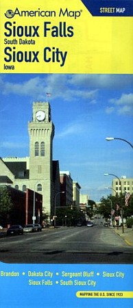 American Maps edition. This full-color street map of Sioux Falls, SD & Sioux City, IA includes: Brandon, Dakota City, Sergeant Bluff, and South Sioux City; and features: Airports, Block Numbers, Colleges and Universities, Golf Courses, Interstate Exit Numbers, Parks and Rec Areas, Places of Interest, Schools, and ZIP Codes.
 - $10.95
Item Code : 9303
Moline, Iowa, America (please turn to "Quad Cities") -
|
Iowa Road Maps |
My Wish List
Last Added Items
You have no items in your wish list.
