
Florida Road Maps | Detailed Travel Tourist Driving
Florida Road Maps
|
| What you’ll find in this section, all arranged in the following order: a. Florida City and County Maps ~ A to N Click Here b. Florida City and County Maps ~ O to Z Click Here c. Florida Fishing Maps Click Here Please look down the list and find the map or atlas of your choice! |
Florida Road Maps
- $17.95
Item Code : TRAL7467
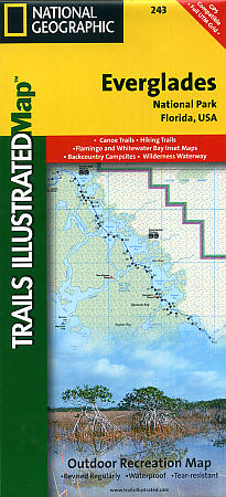
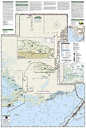 Scale 1:100,000. Size 25"x37". Trails Illustrated edition. Printed on waterproof, tear-resistant, lightweight, paper-like plastic. This is the most comprehensive recreational guide for hiking, boating, paddling, biking, fishing, exploring, camping, and sightseeing in this unique national treasure. This two-sided map includes: Key Largo; Everglades City; Chokoloskee; portions of Big Cypress National Preserve; Fakahatchee Strand State Preserve; Cape Romano Ten Thousand Islands Aquatic Preserve; Shark Valley Tram Road; Old Ingraham highway and campsite; North Nest Key; West Lake Canoe Trail; Snake Bight Trail; Backcountry campsites, beach sites, ground sites, and chickees; detailed insets of Flamingo, Whitewater Bay, Pineland Trails of the Long Pine Key area, and Nine Mile Pond. The map also shows the entire Wilderness Waterway, from the Gulf Coast Visitor Center near Everglades City to its terminus beyond the Flamingo Visitor Center. Includes UTM grids for use with your GPS.
 - $10.95
Item Code : RAND7468
 Scale 1:44,000. Size 25"x37". Rand McNally edition.
 - $10.95
Item Code : UNIV7469

 Scale 1:31,000. Size 28"x40". Universal Map edition.
 - $10.95
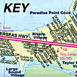
Item Code : AMER7470
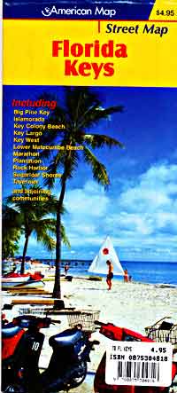
 "Various scales". Size 24"x37". American Map Company edition.
 - $17.95
Item Code : ITMB7472

Scale 1:120,000. Size 28"x39". Indexed. International Travel Maps edition.
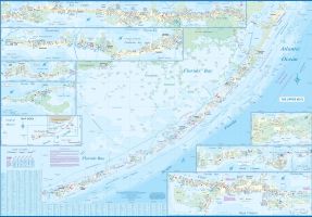
The southern tip of Florida is interesting, but the chain of islands stretching far into the Caribbean are fascinating. The glorified sandbanks are actually Cayes (or Keys in American), all joined together by Highway
1. The map itself consists of a series of inset maps, with side 1 starting from the mainland via one of two bridges and extending south-westerly to Marathon, with detailed insets of the major urban areas along the route, such as Key Largo and Venetian Shores.
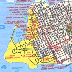
The second side continues all the way to Key West, which is the largest urban area and, in my opinion, the most touristic. Considerably further west of land’s end, and only accessible by boat, are the Dry Tortugas, with Fort Jefferson, now a museum, being the only building in the National Park.
It’s a two-hour boat ride, but well-worth the effort! Apart from its significance as being the most southerly point of the USA, it is also home to the Hemingway Museum, where he lived for a decade and wrote most of his novels. This is a map one really needs to explore such an unusual corner of the USA!
- $10.95
Item Code : MEAS7473
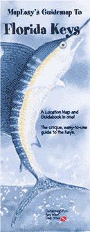
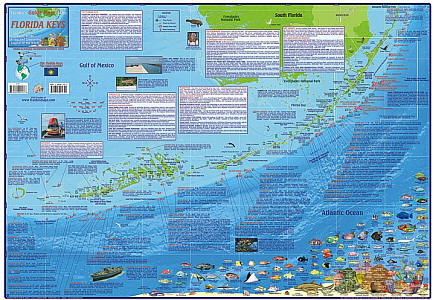
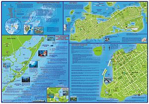
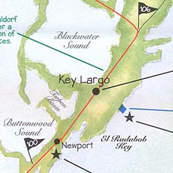 Scale 1:600,000. Size 14"x18". Map Easy edition. The Florida Keys are a stunningly beautiful section of the US. Connected by an elaborate series of bridges and causeways, including one that is seven miles long, the Keys are interesting to explore and great fun! Come along with us as we explore each community along the way. Learn about the history of Key Largo, the best spot for crab on Islamorada, and the numerous dive sites along the way. Once in Key West, MapEasy will direct you through the shopping on Duval Street, and to some of the best restaurants in town. The Florida Keys Guidemap includes detailed sections for Key West and Dive Sites. Perfect for the intrepid or armchair traveller, this charming map combines the best of a guidebook and a location map, all in one. The map is color coded to include information about the city's hotels, restaurants, shops, and sites. Printed on tear-proof, water-resistant, lightweight, paper-like plastic, that is incredibly durable. Also includes sketches of the landscape and interesting details about the area. You'll love this map!
 - $14.95
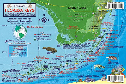
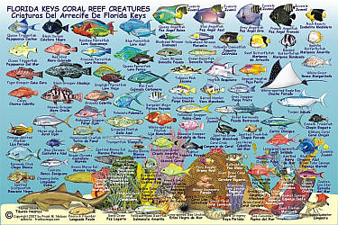
Item Code : FRKO7474
 Size 18?"x26?". Franko maps edition. Printed on waterproof, rip-proof plastic. Laminated
 - $10.95
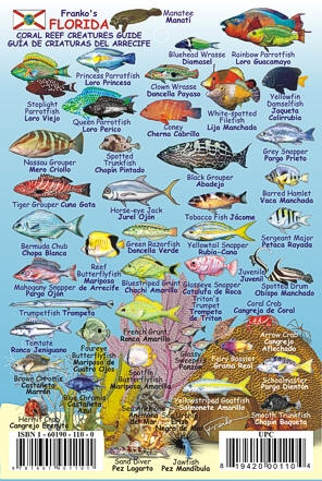
Item Code : FRKO7475
 Size 6"x9". Franko maps edition. Laminated.
 - $10.95
Item Code : FRKO7476
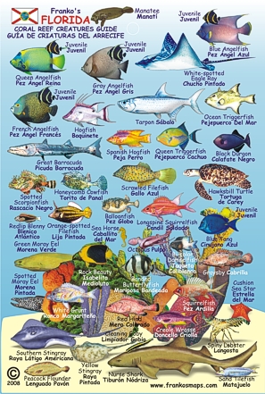 Size 4"x6". Franko maps edition. Laminated.
 - $29.95
Item Code : NATL20956
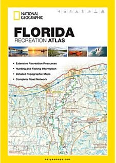
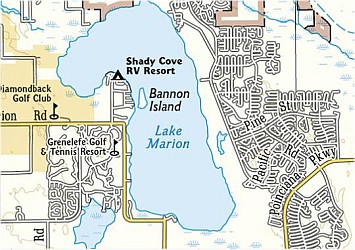 Scale 1:200,000. Size 11"x15". National Geographic edition. National Geographic's Florida Recreation Atlas is an ideal recreation resource and contains accurate, detailed topographic maps with private and public land boundaries, a complete road network, valuable recreation information, and extensive cross-referenced lists and charts for campgrounds, lakes, parks, attractions, and more. State Game Management Unit maps and fish species lists appeal to the sportsman while detailed primary road networks are of great interest to motorcyclists, RVers, and those simply touring the state. Detailed topographic maps with shaded relief for the entire state Each labeled feature is up to date and verified by satellite image Comprehensive, easy-to-read road network Boundaries for parks and federal lands Clearly labeled lakes, rivers, and streams Durable laminated cover Robust travel and recreation information Cross-referenced chart of fishing areas with species information Game management units Campgrounds and attraction charts State Parks maps and facilities Hiking, golfing, and paddling destinations Climate information
 - $16.95
Item Code : NATL21057
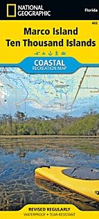
 Scale 1:40,000. Size 26"x38". National Geographic edition. National Geographic's Marco Island - Ten Thousand Islands Coastal Recreation map is the ideal companion for adventures along shore and on the water. National Geographic's new family of Coastal Recreation maps are two-sided, waterproof maps designed specifically for recreation along America's most beautiful shorelines. These hybrid maps strike the perfect balance between professional boating charts and detailed topographic maps for land. There is no other map in the market today that provides as much versatility for coastal recreation as National Geographic's Coastal Recreation series. For paddlers, sail, and power boaters these maps are ideal for planning, cover waters up to three nautical miles off-shore, conveniently sized for use on-board a craft of any size, packed with essentially boating information, and a valuable safety companion. Beach-goers, wildlife enthusiasts, and those that enjoy exploring coastal towns will find these maps an invaluable resource for local beaches, parks, wildlife viewing areas, lighthouses, and unique places of interest. The Marco Island/ Ten Thousand Islands Coastal Recreation map covers SW Florida from Rookery Bay to the Everglades at a scale of 1:40,000 (one inch equals 0.63 Miles). The front side of the map details the northern extent of the Everglades, Everglades City, Marjory Stoneman Douglas Wilderness, Ten Thousand Islands and the southern end of Collier Seminole State Park. The reverse, with overlapping coverage, details Marco Island, Rookery Bay, Romano Shoals and Point Romano, and Collier Seminole State Park. The Marco Island / Ten Thousand Islands map is designed and printed in the United States on durable synthetic paper, making it waterproof, tear-resistant and capable of going anywhere you do. The map is two-sided, and is folded to a convenient size of 4.25" x 9.25"; unfolded size is 26" x 38". These maps fit easily in lifejacket, center console, or glove box.
 - $16.95
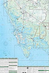
Item Code : NATL21075
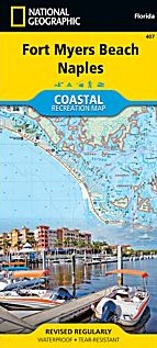
 Scale 1:63,330. Size 26"x38". National Geographic edition. National Geographic's Fort Myers Beach - Naples Coastal Recreation map is the ideal companion for adventures along shore and on the water. National Geographic's new family of Coastal Recreation maps are two-sided, waterproof maps designed specifically for recreation along America's most beautiful shorelines. These hybrid maps strike the perfect balance between professional boating charts and detailed topographic maps for land. There is no other map in the market today that provides as much versatility for coastal recreation as National Geographic's Coastal Recreation series. For paddlers, sail, and power boaters these maps are ideal for planning, cover waters up to three nautical miles off-shore, conveniently sized for use on-board a craft of any size, packed with essentially boating information, and a valuable safety companion. Beach-goers, wildlife enthusiasts, and those that enjoy exploring coastal towns will find these maps an invaluable resource for local beaches, parks, wildlife viewing areas, lighthouses, and unique places of interest. The Fort Myers Beach - Naples Coastal Recreation map covers the SW Florida coast from Estero Bay and the eastern tip of Sanibel Island south to Rookery Bay at a detailed scale of 1:40,000 (1" = 0.63 Mile). The front side of the map details Estero Bay, Fort Myers, Bonita Beach, Hickory Bays and the north end of Delnor Wiggins Pass State Park. The reverse, with overlapping coverage, details the coastline from Delnor-Wiggins Pass State Park, Naples, Clam Pass, Gordon, Pass and Rookery Bay. The Fort Myers Beach - Naples map is designed and printed in the United States on durable synthetic paper, making it waterproof, tear-resistant and capable of going anywhere you do. The map is two-sided, and is folded to a convenient size of 4.25" x 9.25" ; unfolded size is 26" x 38". These maps fit easily in lifejacket, center console, or glove box. Key Features: Waterproof and tear-resistant Updated regularly Designed and printed in the U.S.A Detailed shoreline Bathymetry with marine aids to navigation Marinas, boat ramps, and access points. Beaches, shoreline parks, and wildlife refuges Detailed topography with clearly marked trails for hiking, paddling, biking, powersports, horseback riding, and more Color-coded boundaries for parks, recreation areas, wilderness areas, sanctuaries and wildlife refuges Hundreds of places-of-interest, including: beaches, lighthouses, campgrounds, information centers, trailheads, viewpoints, boat launches, canoe carry downs, fishing access points, scuba diving hot spots, and specialty content unique to each area UTM and Latitude/Longitude grid, as well as selected waypoints and a scale bar for easy and accurate navigation.
 - $11.95
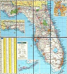
Item Code : RAND22652
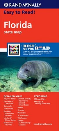
 Rand McNally edition. Rand McNally's Easy To Read State Folded Map is a must-have for anyone traveling in and around Florida, offering unbeatable accuracy and reliability at a great price. Our trusted cartography shows all Interstate, U.S., state, and county highways, along with clearly indicated parks, points of interest, airports, county boundaries, and streets. The easy-to-use legend and detailed index make for quick and easy location of destinations. You'll see why Rand McNally folded maps have been the trusted standard for years. Regularly updated, full-color maps Larger map with a bigger type size than the Rand McNally Folded Map Clearly labeled Interstate, U.S., state, and county highways Indications of parks, points of interest, airports, county boundaries, and more Mileage and driving times map Detailed index Convenient folded size Detailed maps of: Daytona Beach, Fort Myers/Cape Coral, Gainesville, Jacksonville, Key West, Downtown Key West, Lakeland/Winter Haven, Melbourne/Titusville, Miami & Vicinity, Downtown Miami & Miami Beach, Naples, Orlando, Pensacola, St. Augustine, Tallahassee.
 - $11.95
Item Code : RAND22653
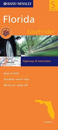
 Rand McNally edition. The durable and convenient Florida EasyToFold state map will take all the wear and tear your journey can dish out. The heavy-duty laminated design allows you to mark your route, make notes, then wipe the surface clean for further use. This is a must-have for navigation whether you're a state resident or just passing through.
 - $10.95
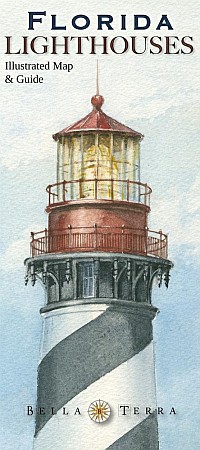
Item Code : BELA22689

 Bella Terra maps edition. The illustrated map and guide to all Florida lighthouses. All standing and "lost" lighthouses in Florida are located on a detailed state map. History and description of each lighthouse. Directions to each light or best viewing spots. 33 original watercolor illustrations. Directory of lighthouse cruises, sightseeing flights and island ferries. Lighthouse and maritime museums listed and located on map. True tales of Florida lighthouses. Paper, 36" x 24", folded to 4" x 9", printed two sides.
 - $14.95
Item Code : BELA22690
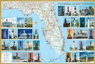 Bella Terra maps edition. The illustrated map and guide to all Florida lighthouses. All standing and "lost" lighthouses in Florida are located on a detailed state map. History and description of each lighthouse. Directions to each light or best viewing spots. 33 original watercolor illustrations. Directory of lighthouse cruises, sightseeing flights and island ferries. Lighthouse and maritime museums listed and located on map. True tales of Florida lighthouses. Paper, 36" x 24", folded to 4" x 9", printed two sides.
 - $13.95
Item Code : HAMD7431
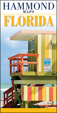 Size 6"x9" (folded). Hammond International edition. The Florida Hammond Map is a brand new title in this series of quality road maps and atlases for the discriminating traveler. The map covers the entire state of Florida, plus the Bahamas, Cuba and Jamaica. Also included is a large-scale map of Greater Miami and a downtown Miami street map. Fully digitized cartography, a comprehensive index and distance indicators printed on premium paper with an attractive, durable cover, make it the perfect travel companion for any exciting journey.
 - $229.95 + $24.80 p&h (add $40 for spring rollers)
Item Code : UNIV7446
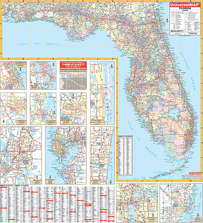 Size 54" W x 56" H. Laminated. Printed in color with a markable and washable laminated surface. Cities and counties are indexed on the face of the map. Railed wall maps can be turned into pull down maps on spring rollers for an additional $40. Identifies major airports, state universities, state and national parks, all state and federal highways, secondary roads, major waterways, cities and towns, and military installations. Detailed insets of the following major cities and areas: Daytona Beach, St. Petersburg, Jacksonville, Tampa, Gainesville, Tallahassee, Orlando, Kennedy Space Center, Ft. Lauderdale, St. Augustine, Miami. Features color-coded counties along with new and old highway exit numbers.
 - $229.95 + $24.80 p&h (add $40 for spring rollers)
Item Code : UNIV7447
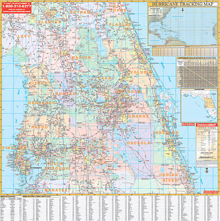 Size 54" W x 56" H. Laminated. This 4th edition of the Central Florida Wall Map includes Brevard County, Citrus County, Flagler County, Hernando County, Hillsborough County, Indian River County, Lake County, Levy County, Marion County, Orange County, Osceola County, Pasco County, Pinellas County, Polk County, Seminole County, Sumter County, and Volusia County. Details are as follows: state and county roads, US Highways, Interstate Highways, mileage circles, ZIP codes and boundaries, longitude and latitude lines, new and old exit numbers, and an index on the face of the map. A special feature is a hurricane charting map. Contains up-to-date cartography with new streets and changes. The laminated surface is both markable, washable and in color. Framing rails are included on top and bottom for easy wall mounting. Railed wall maps can be turned into pull down maps on spring rollers for an additional $40.
 - $229.95 + $24.80 p&h (add $40 for spring rollers)
Item Code : UNIV7448
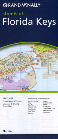
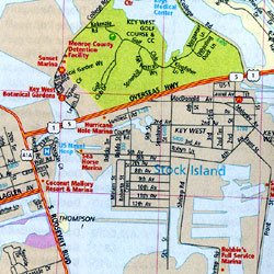
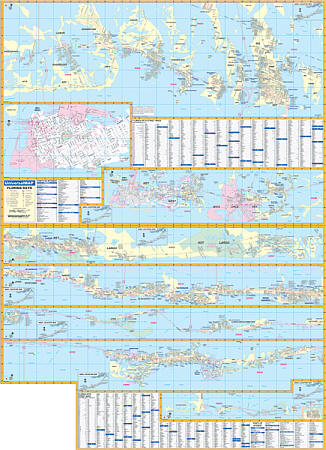 Size 46" W x 62" H. Laminated. The Florida Keys Wall Map is published by Universal Map. Printed in color with a markable and washable laminated surface. Mounted on hanging rails. The area of coverage includes seven connecting sections showing the entire Florida Keys in complete detail from Key West to Key Largo. Contains an enlarged scale inset map of Key West. Details: all streets/highways, educational facilities, golf/country clubs, shopping centers, resorts/marinas, recreational parks/campgrounds, city limits/annexations, airports/railroads, hospitals, fire/police stations, water features, government buildings, cemeteries, post offices, ZIP codes/boundaries, mile markers, and points of interest. Railed wall maps can be turned into pull down maps on spring rollers for an additional $40.
| Postage and handling is $3.50 for the first map and $1.50 for each additional map. ~ ~ ~ ~ ~ ~ Foreign delivery is $7.80 for the first map and $5.00 for each additional map. |
| ** Click here! to view our collection of Florida Travel VIDEOS ** |
Florida Road Maps
|
| What you’ll find in this section, all arranged in the following order: a. Florida City and County Maps ~ A to N Click Here b. Florida City and County Maps ~ O to Z Click Here c. Florida Fishing Maps Click Here Please look down the list and find the map or atlas of your choice! |
