
Alabama Road Maps | Detailed Travel Tourist Driving
All Roads Leading to Alabama - Road Maps
Alabama is located on the Gulf Coast and there are four states bordering it;Tennessee in the north, Georgia in the east, Florida in the south, and Mississippi in the west. The southern hospitality, its culture, racing, fine dining, and history allures tourists.
Interstate 59, Interstate 65 and Interstate 85 are the interstates running from North to South and Interstate 10 and Interstate 20 are East to West interstates. There is lots more to know about Alabama and the road maps will take you all through the cities with 11 routes.
The interstate 65 (I-65) is the longest and a major route covering 367.00 miles or 590.63 km linking six largest cities and facilitate travel between Alabama and its neighboring states. It begins from the southern terminus in Mobile and extends north through Montgomery and Birmingham and enters Tennessee.
You can drive to Georgia from the western terminus in Montgomery by taking the Interstate 85 (I-85) or from Birmingham by taking I-59 northeast.While I-10 bisects Mobile in southern Alabama and links Mississippi and Florida.
Alabama has a spectacular roadway in the world, travelers will find scenic byways enjoyable with the Appalachian Highlands Scenic Byway with the natural beauty of the Appalachian Mountains in the backdrop with lush green vegetation, fascinating geologic structures,and picturesque historical rural communities.
If you wish to go on a long drive then there are ten unforgettable scenic byways with some of the most amazing views of Alabama. You must drive through these:
- The Natchez Trace Parkway
- Lookout Mountain Parkway
- Selma to Montgomery March Byway
- Alabama's Coastal Connection Scenic Byway
- Barbour County Governors' Trail
- Talladega Scenic Drive
- Cheaha State Park Road
- Huntsville Mountaintop Road
- Black Warrior River Scenic Byway
- The Oak Alley
With the Alabama road map, you will be able to identify the best roads for a leisure drive even if you live in Alabama.
Alabama Road Maps for Tourists and TravelersDetailed Road Map of AlabamaBuy travel maps for Alabama tourist attractions, road trips, street guide, driving directions and more |
Alabama Road Maps
- $249.95 + $24.80 p&h (add $40 for spring rollers)
Item Code : KAPA21083
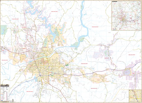 Our Tuscaloosa, AL Wall Map, with adjacent areas, measures 73" x 53" (6'1" W x 4'5" H) and features up-to-date cartography, with new streets and changes in complete street detail; is printed in color, with a markable and washable laminated surface; and offers a street index in a separate book-format. The area of coverage includes all of the City of Tuscaloosa, with the following boundaries: - North to Old Lock 15 Park - South to the intersection of CR 95 and AL 69 - East to the Town of Vance - West to the Town of Coker The Tuscaloosa, AL Wall Map also includes an inset map of Downtown Tuscaloosa and a detailed Tuscaloosa County map. Details and features include: - AIRPORTS - BLOCK NUMBERS - CEMETERIES - CITY LIMITS (color-coded) - COMMUNITY NAMES - EDUCATIONAL INSTITUTIONS - GOLF & COUNTRY CLUBS - GOVERNMENT BUILDINGS - HOSPITALS - POINTS OF INTEREST - POST OFFICES - RAILROADS - RECREATIONAL PARKS - SHOPPING CENTERS - STREETS & HIGHWAYS - WATER FEATURES - ZIP CODE BOUNDARIES Framing rails are included, top and bottom, for easy wall mounting. Spring roller mounting is also available, for an additional $40.
All Roads Leading to Alabama - Road Maps
Alabama is located on the Gulf Coast and there are four states bordering it;Tennessee in the north, Georgia in the east, Florida in the south, and Mississippi in the west. The southern hospitality, its culture, racing, fine dining, and history allures tourists.
Interstate 59, Interstate 65 and Interstate 85 are the interstates running from North to South and Interstate 10 and Interstate 20 are East to West interstates. There is lots more to know about Alabama and the road maps will take you all through the cities with 11 routes.
The interstate 65 (I-65) is the longest and a major route covering 367.00 miles or 590.63 km linking six largest cities and facilitate travel between Alabama and its neighboring states. It begins from the southern terminus in Mobile and extends north through Montgomery and Birmingham and enters Tennessee.
You can drive to Georgia from the western terminus in Montgomery by taking the Interstate 85 (I-85) or from Birmingham by taking I-59 northeast.While I-10 bisects Mobile in southern Alabama and links Mississippi and Florida.
Alabama has a spectacular roadway in the world, travelers will find scenic byways enjoyable with the Appalachian Highlands Scenic Byway with the natural beauty of the Appalachian Mountains in the backdrop with lush green vegetation, fascinating geologic structures,and picturesque historical rural communities.
If you wish to go on a long drive then there are ten unforgettable scenic byways with some of the most amazing views of Alabama. You must drive through these:
- The Natchez Trace Parkway
- Lookout Mountain Parkway
- Selma to Montgomery March Byway
- Alabama's Coastal Connection Scenic Byway
- Barbour County Governors' Trail
- Talladega Scenic Drive
- Cheaha State Park Road
- Huntsville Mountaintop Road
- Black Warrior River Scenic Byway
- The Oak Alley
With the Alabama road map, you will be able to identify the best roads for a leisure drive even if you live in Alabama.
Alabama Road Maps for Tourists and TravelersDetailed Road Map of AlabamaBuy travel maps for Alabama tourist attractions, road trips, street guide, driving directions and more |
