
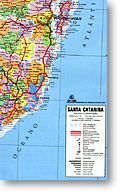
Santa Catarina State Road and Political Map, Brazil.
$14.95
In stock
Scale 1:700,000. Size 35"x26" ( = 90x65 cms). Geomapas edition. Shows all the political subdivisions (about 150 of them) in different colors, and features road types and numbers, distances between points in kilometers, airports, seaports, and points of interest. Also includes a distance table in kilometers. The principal cities of Santa Catarina State are Florianapolis, Blumenau, and Joinvile. Laminated. Very detailed.
Scale 1:700,000. Size 35"x26" ( = 90x65 cms). Geomapas edition. Shows all the political subdivisions (about 150 of them) in different colors, and features road types and numbers, distances between points in kilometers, airports, seaports, and points of interest. Also includes a distance table in kilometers. The principal cities of Santa Catarina State are Florianapolis, Blumenau, and Joinvile. Laminated. Very detailed.
| Item Price | $14.95 |
|---|
Write Your Own Review