
New York State Road Maps | Detailed Travel Tourist Driving
|
~ New York State Road Maps ~ |
New York State
- $269.95 Rolled + $24.80 p&h
Item Code : UNIV11364
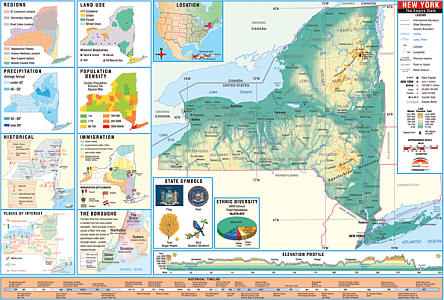 Size 54"x64". Universal Map edition. Laminated. Intermediate Thematic Wall Maps Grades 3-8 Colorful, oversized cartography makes these state maps the perfect teaching aide for state studies. Laminated with a heavy-duty washable finish that can be written on by water based and dry erase markers. The Thematic Wall Map series includes a spring roller with blackboard. The Intermediate thematic Wall Maps feature a historical timeline and elevation profile, plus insets of land use, ethnic diversity, and population, average precipitation, and more. Corresponds with the Thematic Deskpad Maps.
 - $269.95 Rolled + $24.80 p&h
Item Code : UNIV11365
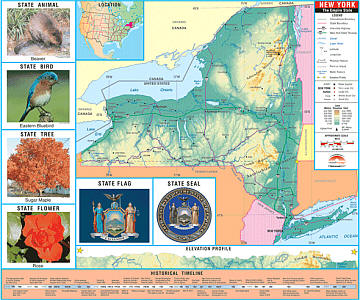
 Size 54"x64". Universal Map edition. Laminated. The New York Thematic K-2 Wall Map is the perfect teaching aid for state studies and related subjects. Political/physical maps with hypsometric colorations. Shows county boundaries, interstate highways, county seats, cities and towns and state regions. Maps correlate with state standards and curriculum guidelines. They are constructed of heavy paper with a write-on wipe-off laminated finish that can be used with water based or dry erase pens. Mounted on spring roller with backboard. K-2 Wall Map features basic state information. Shows state capital and major cities, state flag, state seal and motto, state tree, flower and bird. Measures 62" wide, length varies. Corresponding deskpad map matches with the information on the K-2 wall map. Two sided with markable/ washable finish makes it ideal for student testing. Order individually or in sets of 30 with markers and convenient storage box. This product is ideal for public, private, parochial, and home schools.
 - $449.95 Rolled + $24.80 p&h
Item Code : UNIV11366
 Size 54"x64". Universal Map edition. Laminated. The New York Thematic K-2 Wall Map is the perfect teaching aid for state studies and related subjects. Political/physical maps with hypsometric colorations. Shows county boundaries, interstate highways, county seats, cities and towns and state regions. Maps correlate with state standards and curriculum guidelines. They are constructed of heavy paper with a write-on wipe-off laminated finish that can be used with water based or dry erase pens. Mounted on spring roller with backboard. K-2 Wall Map features basic state information. Shows state capital and major cities, state flag, state seal and motto, state tree, flower and bird. Measures 62" wide, length varies. Corresponding deskpad map matches with the information on the K-2 wall map. Two sided with markable/ washable finish makes it ideal for student testing. Order individually or in sets of 30 with markers and convenient storage box. This product is ideal for public, private, parochial, and home schools.
 - $249.95 + $24.80 p&h (add $40 for spring rollers)
Item Code : KAPA21120
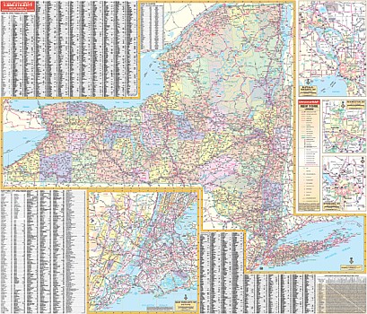 The 3rd edition State of New York Wall Map by Kappa Map Group measures 60” W x 52” H (5' W x 4'4" H) using up-to-date cartography at a scale of 1” = 7 miles. Printed in color with a markable/washable-laminated surface. Cities and counties are indexed on the face of the map. Includes hanging rails mounted top and bottom. Features color-coded counties and a mileage chart between major cities. Details all state and federal highways, secondary roads, cities and towns, major airports, major waterways, state universities, military installations, state/national parks, wildlife areas, and points of interest. Railed wall maps can be turned into pull down maps on spring rollers for an additional $40.
| Postage and handling is $3.50 for the first map and $1.50 for each additional map. ~ ~ ~ ~ ~ ~ Foreign delivery is $7.80 for the first map and $5.00 for each additional map. |
| ** Click here! to view our collection of New York State Travel VIDEOS ** |
|
~ New York State Road Maps ~ |
My Wish List
Last Added Items
You have no items in your wish list.
