
Minnesota Road Maps | Detailed Travel Tourist Driving
|
Minnesota Road Maps |
Minnesota Road Maps
- $10.95
Item Code : HBRG22897
Hedberg Maps edition. - $10.95
Item Code : HBRG22898
Hedberg Maps edition. - $249.95 + $24.80 p&h (add $40 for spring rollers)
Item Code : KAPA21114
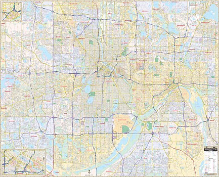 The Minneapolis/St. Paul, MN Wall Map by Kappa Map Group measures 73" W x 59" H and provides complete street detail with new streets and changes. The laminated surface is both markable and washable. Street indexing appears in a separate book. The area of coverage ranges: North: to include all of the City of New Brighton and White Bear Lake; South: to include all of the City of Bloomington; East: to the Ramsey County line and all of the City of Newport; West: covers all of the City of Minnetonka and Plymouth. Other details included are as follows: airports, post offices, hospitals, railroads, points of interest, mileage circles, longitude and latitude lines, all streets and highways, cemeteries, shopping centers, water features, recreational parks, block numbers, government buildings, fire and police stations, educational facilities, golf courses and country clubs, ZIP codes and their boundaries, and city limits and annexations. Framing rails are included on top and bottom for easy wall mounting. Railed wall maps can be turned into pull down maps on spring rollers for an additional $40.
 - $249.95 + $24.80 p&h (add $40 for spring rollers)
Item Code : UNIV10699
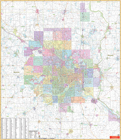 Scale 1:7,833. Laminated. Printed in color with a markable and washable laminated surface. Cities are indexed on the face of the map. Details include major streets and all highways, ZIP codes and boundaries, latitude and longitude lines, county lines and names, parks, golf courses, amusement centers and stadiums, water features, government buildings and federal penitentiaries, military institutions and airports, hospitals and cemeteries, and mileage circles. Boundaries include Foley, MN and Trade River, WS to the north; extend south to Montgomery, MN and Northfield, MN; include River Falls, WS and Red Wing, MN to the east, and extend west to Winsted, MN and Clear Water, MN. Railed wall maps can be turned into a pull down map on spring rollers for an additional $40.
 - $29.95
Item Code : NATL20989
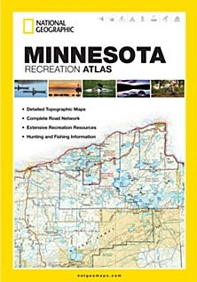
 Scale 1:175,000. Size 11"x15". National Geographic edition. National Geographic's Minnesota Recreation Atlas is an ideal recreation resource and contains accurate, detailed topographic maps with private and public land boundaries, a complete road network, valuable recreation information and extensive cross-referenced lists and charts for campgrounds, lakes, parks, attractions, and more. State Game Management Unit maps and fish species lists appeal to the sportsman while detailed primary road networks are of great interest to motorcyclists, RVers, and those simply touring the state. Key features: Detailed topographic maps with shaded relief for the entire state Each labeled feature is up to date and verified by satellite image Comprehensive, easy-to-read road network Boundaries for parks and federal lands Clearly-labeled lakes, rivers and streams Durable laminated cover Robust travel and recreation information Cross-referenced chart of fishing areas with species information Game management units Campgrounds and attraction charts State Parks maps and facilities Hiking, golfing, skiing and paddling destinations Climate information.
 - $10.95
Item Code : HBRG22902
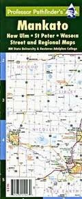 Hedberg Maps edition. Includes regional map showing routes to the Twin Cities and I-35W, and street maps of Mankato, North Mankato, Waseca, New Ulm, and St Peter. Also includes campus maps of Minnesota State University, Mankato, and Gustavus Adolphus University. Streets are indexed. Six-panel accordion fold for easy open and close. UV coated for added durability.
 - $10.95
Item Code : RAND10705
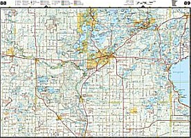
 Scale 1:40,000. Size 23"x29". Rand McNally edition.
 - $10.95
Item Code : HBRG22900
Hedberg Maps edition. A useful compact map for the most traveled portion of the state. A detailed and legible highway map covering from Hinckley to the Iowa border is combined with a Twin Cities metro map along with detailed metro insets of 16 other cities: Albert Lea, Austin, Fairmont, Faribault, Hutchinson, La Crosse (WI), Mankato, Marshall, New Ulm, Northfield, Owatonna, Rochester, St Cloud, Willmar, Winona, and Worthington. Indispensable to the outstate driver! Six-panel accordion-style fold for easy open/close. Printed on card stock and UV coated for durability. Used copies of this map might have an older publication date. New copies purchased directly from Amazon will have the most recent publication date. - $10.95
Item Code : RAND10707
 Scale 1:30,000. Size 19"x25". Rand McNally edition.
 - $10.95
Item Code : RAND10708
 Scale 1:37,000. Size 28"x39". Rand McNally edition.
 - $10.95
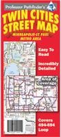
Item Code : HBRG22894

 Hedberg Maps edition. Covering the I-494-694 loop, including the entire cities of Minneapolis and St Paul, this detailed map shows streets, parks, schools, shopping, trails, government offices and an amazing wealth of points of interest.
 - $43.95
Item Code : HUDS10698
Paul), Deluxe Metro Street ATLAS, Minnesota, America. Scale 1:36,000. Hudson Map Company edition. - $10.95
Item Code : RAND22899
 Rand McNally edition. The map also covers Brooklyn Park, Burnsville, Eagan, Eden Prairie, Cottage Grove, Maple Grove, Minnetonka, Plymouth, Roseville, and Woodbury.
|
Minnesota Road Maps |
