
Brazil Road Maps | Detailed Travel Tourist Driving
Be a Localite in South America’s Biggest Country with our Maps
Brazil is the biggest country officially of South America. The total area of this country is nearly 8,456,511 square kms. It stretches from Amazon basin in the north to the massive lguacu Falls in the South. The country is very famous because of its beaches and the flamboyant costumes. The people of Brazil are fun loving, it hardly matters to them what day of celebration it is, they just enjoy the same. People of Brazil don’t wait for occasion to celebrate; every day is a celebration day for them.
The country has the biggest road network in the world. The biggest cities in the country include Sao Paulo, Rio De Janeiro, and Salvador. The country has the fourth largest highway network in the entire world. People in the country usually travel interstate by Cargo/Ships rather taking the road route. One who take the road route prefer going by highways. If we take the entire road network as 100%, the fact is that over 90% of the roads in the country are unpaved, only 10% of roads are paved roads.
Explore the wonderful roads of Brazil with our maps, and easily reach your destination in time by using our user-friendly maps which are easily readable and makes you understand and plan your trip in advance after considering the road stop page, refilling time and many other factors. The routes of Air travel is defined with a beautiful and vibrant color which makes it interesting for the viewers to understand and read the map easily. The map is user-friendly and so easily readable that even my grand daughter will love to read it any day and even enjoy traveling with this map which makes her travel properly defined without any hassle. You can also enjoy the same in case you plan your next city expedition with our maps.
Brazil Road Maps for Tourists and TravelersDetailed Road Map of BrazilBuy travel maps for Brazil tourist attractions, road trips, street guide, driving directions and more |
Brazil Road Maps
- $14.95
Item Code : GMAP5569
Scale 1:550,000. Size 26"x35" ( = 65x90 cms). Geomapas edition. Shows all the political subdivisions (about 100 of them) in different colors, and features road types and numbers, distances between points in kilometers, distances within the state from Vitoria, airports, seaports, and points of interest. Also includes a distance table in kilometers. The principal cities of Espirito Santo State are Vila Velha, Vitoria, Linhares, and Colatina. Laminated - $14.95
Item Code : GMAP5570
Scale 1:1,400,000. Geomapas edition. Includes political subdivisions. Laminated - $14.95
Item Code : GMAP5573
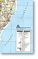 Scale 1:1,700,000. Size 46" across x 35" high ( = 90x65 cms). Geomapas edition. Shows all the political subdivisions (about 200 of them) in different colors, and features road types and numbers, distances from Belo Horizonte in kilometers, airports, seaports, and points of interest. Also includes a distance table in kilometers. Laminated. I love this map! SAMPLE MAP
 - $14.95
Item Code : GMAP5571
Scale 1:1,500,000. Geomapas edition. Includes political subdivisions. Laminated - $14.95
Item Code : GMAP5572
Scale 1:1,500,000. Size 49" across x 70" high (92x126 cms). This is a big map! Indexed. Geomapas edition. Shows all types of roads, road numbers, distances between points in kilometers, cities, towns, villages, airports, harbors, points of interest, and all the political subdivisions (about 100 of them) within the state, in different colors. Laminated. SAMPLE MAP - $17.95
Item Code : QATR5574
Scale 1:1,700,000. Qatro Rodas edition. - $14.95
Item Code : QATR5563
 Scale 1:3,700,000. Qatros Rodas edition. Includes the states of Amazonas, Para, Amapa, Rondonia, Acre, and Tocantins.
 - $14.95
Item Code : QATR5561
 Scale 1:2,400,000. Qatros Rodas edition. Includes the states of Ceara, Rio Grande do Norte, Paraiba, Maranhao, Piaui, Pernambuco, Alagoas, and Sergipe. SAMPLE MAP
 - $14.95
Item Code : GMAP5575
Scale 1:1,700,000. Geomapas edition. Includes political subdivisions. Laminated - $14.95
Item Code : GMAP5577
Size 46" across x35" high ( = 90x65 cms). Indexed. Geomapas edition. Shows all the political subdivisions (about 100 of them) in different colors, and features road types and numbers, airports, seaports, and points of interest. Also includes a distance table in kilometers. The principal cities in Paran? State are Curitiba and Londrina. Laminated. SAMPLE MAP - $14.95
Item Code : QATR5576
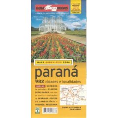 Comprehensive road map. All legends and text are in Portuguese, but easy to understand. Main map shows locations of hundreds of cities and towns as well as toll roads, service stations, police stations, ferries, distance between points, and highway numbers with an index of place names. The reverse side features a 1:11,000 scale map of Curitiba city center with street index, distance chart, and seven route guides for driving between major cities. Printed on two sides.
 - $14.95
Item Code : GMAP5578
Scale 1:500,000. Geomapas edition. Includes political subdivisions. Laminated - $14.95
Item Code : TRES5579
Scale 1:400,000. Trieste edition. Laminated - $14.95
Item Code : QATR5580
Scale 1:1,500,000. Qatro Rodas edition - $14.95
Item Code : GMAP5581
Scale 1:900,000. Geomapas edition. Includes political subdivisions. Laminated - $14.95
Item Code : GMAP5582
Scale 1:1,000,000. Geomapas edition. Includes political subdivisions. Laminated - $14.95
Item Code : GMAP5583
Scale 1:1,100,000. Geomapas edition. Includes political subdivisions. Laminated - $14.95
Item Code : GMAP5585
Scale 1:1,000,000. Geomapas edition. Includes political subdivisions. Laminated - $14.95
Item Code : TRES5586
Scale 1:1,000,000. Size 43"x32?". Trieste edition. Indexed. Shows all major roads and secondary roads, plus distances between points in kilometers, as well as railway lines, ports, airports, tourist sites, and camping areas. Also includes a large inset map of the principal roads in and out of Sao Paulo that notes the names of all the neighborhoods (districts) within the metropolitan Sao Paulo area. Very useful. Laminated -
| Postage and handling is $4.40 for the first map and $1.80 for each additional map. ~ ~ ~ ~ ~ ~ Foreign delivery is $15.80 for the first map and $7.60 for each additional map. ~ ~ ~ ~ ~ ~ Canada delivery is $15.80 for the first map and $7.60 for each additional map. |
Be a Localite in South America’s Biggest Country with our Maps
Brazil is the biggest country officially of South America. The total area of this country is nearly 8,456,511 square kms. It stretches from Amazon basin in the north to the massive lguacu Falls in the South. The country is very famous because of its beaches and the flamboyant costumes. The people of Brazil are fun loving, it hardly matters to them what day of celebration it is, they just enjoy the same. People of Brazil don’t wait for occasion to celebrate; every day is a celebration day for them.
The country has the biggest road network in the world. The biggest cities in the country include Sao Paulo, Rio De Janeiro, and Salvador. The country has the fourth largest highway network in the entire world. People in the country usually travel interstate by Cargo/Ships rather taking the road route. One who take the road route prefer going by highways. If we take the entire road network as 100%, the fact is that over 90% of the roads in the country are unpaved, only 10% of roads are paved roads.
Explore the wonderful roads of Brazil with our maps, and easily reach your destination in time by using our user-friendly maps which are easily readable and makes you understand and plan your trip in advance after considering the road stop page, refilling time and many other factors. The routes of Air travel is defined with a beautiful and vibrant color which makes it interesting for the viewers to understand and read the map easily. The map is user-friendly and so easily readable that even my grand daughter will love to read it any day and even enjoy traveling with this map which makes her travel properly defined without any hassle. You can also enjoy the same in case you plan your next city expedition with our maps.
Brazil Road Maps for Tourists and TravelersDetailed Road Map of BrazilBuy travel maps for Brazil tourist attractions, road trips, street guide, driving directions and more |
